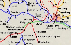
The Newtown Goods Line route maps
The two pages of the Newtown Goods Line are divided into a series of two
modern street maps.
The route of the old railway line is combined with
modern street maps & shows the crossings over or under roads where
possible.
Of course many of the road bridges over the line have now been filled in
underneath & the railway bridges over the roads have been demolished.
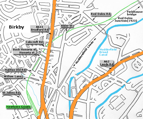
We follow the route northwards from -
Newtown Goods Huddersfield to Mirfield junction.
|
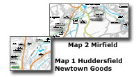
You are here: Map 1 Huddersfield
Newtown Goods - Fieldhouse Bridge |
|
|
 Map 1 Newtown Map 1 Newtown
Newtown goods - Fieldhouse bridge
Midland Newtown to Mirfield line shown in green.
Existing Huddersfield Leeds line shown in black.
|
North Eastern Gas Board Railway 1922 - 1966
Entrance
to The gas works. (12-04-04)
: David Webdale
/14%20gasworks%20east_small.jpg) A rail connection was made from the goods yard to the gas works situated
down on the other side of Leeds road. A rail connection was made from the goods yard to the gas works situated
down on the other side of Leeds road.
The route took it under the L.N.W.R Huddersfield to Dewsbury line, across Bradford road, down
the middle of Beaumont street,
across Leeds road & across the canal. For street working, the steam engines had guard rails
fitted over the wheels.
In the photo the
rails to the left of the building crossed the road here to the other side of the works.
From the
points in front of the kings mill carpets sign, a section of track does
a circular route around the gasometer. |
 Huddersfield
Gasworks Railway Huddersfield
Gasworks Railway
A short exploration of a railway built through the streets
of Huddersfield
to take coal to a gasworks. The site closed in 1972 :
jpbexploration@gmail.com
https://www.youtube.com/watch?v=c964xLeRpwg |
/15%20gasworks%20west_small.jpg) Looking
back towards the entrance. (12-04-04) : David Webdale Looking
back towards the entrance. (12-04-04) : David Webdale
From the points (behind the Kings mill carpets sign)
the track can be seen to veer off to the right, where it crossed the
canal.
Coal was brought in & coke was taken out. A man walked in front of the
engine with a red flag. |
/DSCN0065_small.jpg) Canal
crossing facing east towards gasworks (07-08-16) : David Webdale Canal
crossing facing east towards gasworks (07-08-16) : David Webdale
Between Leeds road bridge & Gasworks street bridge the
track crossed the canal here on a bow string concrete deck bridge. |
/DSCN0063_small.jpg) Canal
crossing facing west towards Leeds road & Beaumont street (07-08-16) : David Webdale Canal
crossing facing west towards Leeds road & Beaumont street (07-08-16) : David Webdale
The other side, concrete supports visible. |
/DSCN0061_small.jpg) Beaumont
street facing east towards gasworks (07-08-16) : David Webdale Beaumont
street facing east towards gasworks (07-08-16) : David Webdale
The remaining short section of Beaumont street, close up
of pothole next photo.
Great Northern street crosses in front, beyond is
the Great Northern retail park & in the distance can be seen the gasometer.
Before the retail park was built Beaumont street carried on
down the other side to Leeds road. |
/DSCN0062_small.jpg) Beaumont
street (07-08-16) : David Webdale Beaumont
street (07-08-16) : David Webdale
Potholes reveal the old tracks & cobbles. |
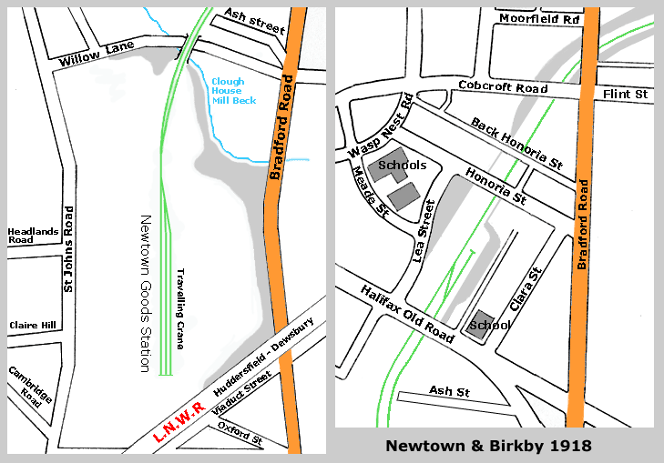
Newtown Goods
 Newtown & Birkby maps 1918 : David Webdale Newtown & Birkby maps 1918 : David Webdale
Left hand map south, right hand map north. |
/22%20ringway%20est%20east_small.jpg) Newtown Goods (Ringway trading estate) facing East (31-05-03) : David
Webdale Newtown Goods (Ringway trading estate) facing East (31-05-03) : David
Webdale
Boring, nothing to see here. The site of Newtown
goods yard, taken from Willow lane
facing towards Huddersfield.
The
original route track route ran somewhere down this road.
It veered off
to the left to cross Willow lane bridge. (see next photo). |
/21willow%20lane%20south_small.jpg) Willow Lane facing South (31-05-03) : David Webdale Willow Lane facing South (31-05-03) : David Webdale
One of my favourite remnants this. I like those
ceramic bricks, reminds me of the London underground.
The brick & stone
archway spans Clough house mill beck. (see Newtown map) Probably an iron
deck bridge spanned Willow lane. |
/23%20hill%20house%20lane%20north_small.jpg) Halifax Old road facing North (31-05-03) : David Webdale Halifax Old road facing North (31-05-03) : David Webdale
Taken with Willow lane just behind, facing toward
Mirfield. Its all gone a bit cycle path now on here,
an attempt to copy
the Spen Valley Greenway I think. The bridge in front carries Halifax
Old road. |
%20%20(08%20to%2023%2007-06-03)%20(24%2008-06-03)/1%20honoria%20st%20north_small.jpg) Honoria
street facing North (01-06-03) : David Webdale Honoria
street facing North (01-06-03) : David Webdale
All this areas been filled in, but access under
the bridges has been maintained.
In this cutting was a siding just to
the right.
(see Birkby map 1918)
The bridge in front carries Honoria
street. |
%20%20(08%20to%2023%2007-06-03)%20(24%2008-06-03)/2%20back%20honoria%20st%20north_small.jpg) Back Honoria street facing North (01-06-03) : David Webdale Back Honoria street facing North (01-06-03) : David Webdale
Another one of my favourite bits. Taken from beneath Honoria street, back Honoria street
crosses in front.
All the streets in this area were built on the Thornhill estate & named after family members.
Honoria is the name of the
second wife of a bloke called William Capel Clarke, who married
into the Thornhill estate.
His first wife was Clara Thornhill.
Clara street joins Honoria street to the right. |
%20%20(08%20to%2023%2007-06-03)%20(24%2008-06-03)/3%20bradford%20rd%20east_small.jpg) Bradford road facing East (01-06-03) : David Webdale Bradford road facing East (01-06-03) : David Webdale
Taken from Cobcroft road. The bridge in front
carries Bradford road. The bridge under here has been filled in & the
remaining stone work has been completely destroyed by over complicated
cycle path gates & stuff, but at least the route has remained open. |
%20%20(08%20to%2023%2007-06-03)%20(24%2008-06-03)/4%20bradford%20rd%20close%20up%20east_small.jpg) Bradford road facing East (01-06-03) : David Webdale Bradford road facing East (01-06-03) : David Webdale
Close up of Bradford road bridge, solid or what. |
%20%20(08%20to%2023%2007-06-03)%20(24%2008-06-03)/5%20alder%20st%20east_small.jpg) Alder street facing East (01-06-03) : David Webdale Alder street facing East (01-06-03) : David Webdale
A bit further on is Alder street bridge, almost
completely filled in. |
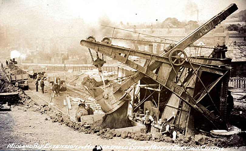
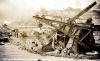 Steam Navvy, Fartown cutting (c1902) : Simon Green Steam Navvy, Fartown cutting (c1902) : Simon Green
This shot kindly donated by Simon Green, showing line under
construction.
From a postcard, post dated 1902.
Writing says "Midland Rly extension Huddersfield Steam Navvy Fartown
Cutting" |
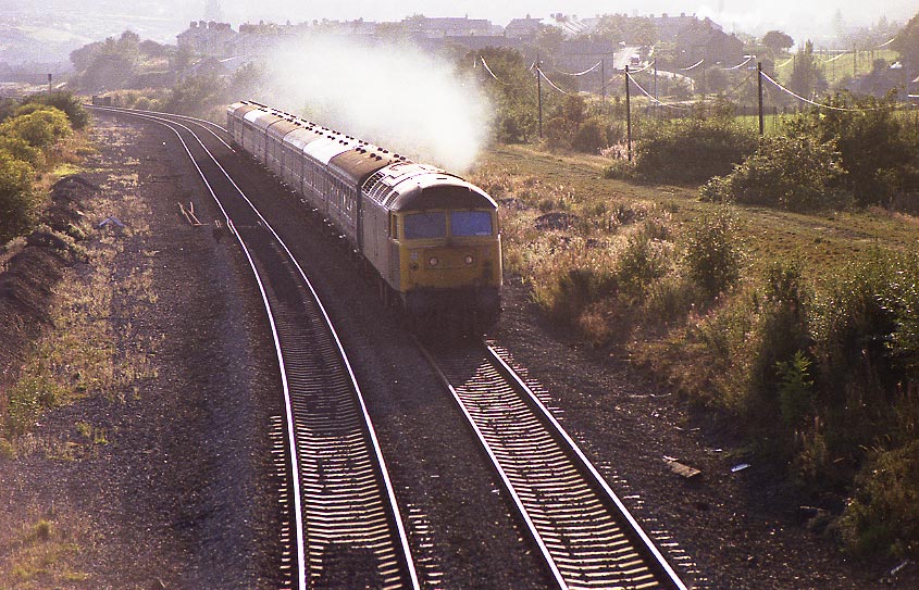
Red Doles facing West (c1980) : David Webdale
 The site of Red Doles junction Taken from
Fieldhouse bridge, facing towards Huddersfield. The site of Red Doles junction Taken from
Fieldhouse bridge, facing towards Huddersfield.
A picturesque 1980s
photo of a 47 hauled passenger on its
way to Leeds. The Newtown goods
track bed can be seen on the right.
The bridge over Red Doles road is
just visible in top left.
Way back in the 12th century this area was used for growing high quality
grass by a method of flooding.
The "doles" were the shares of individual tenants marked out by stones &
the word red is derived from "reed". |
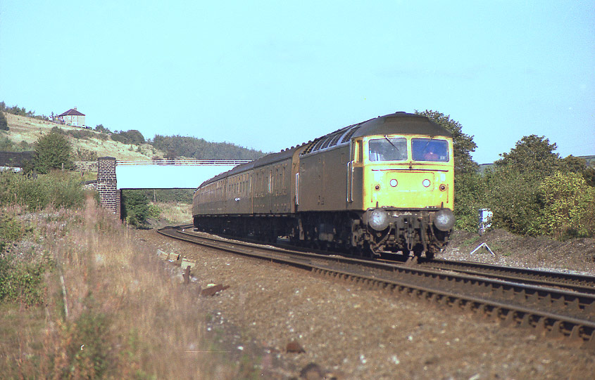
 Fieldhouse bridge facing East (c1980)
: David Webdale Fieldhouse bridge facing East (c1980)
: David Webdale
Facing back towards Leeds, a 47 passenger on its
way to Huddersfield. Fieldhouse bridge in background.
To the left of
photo can be seen the bit where it crosses the Newtown goods line.
(see
next photo). |
%20%20(08%20to%2023%2007-06-03)%20(24%2008-06-03)/6%20red%20doles%20footpath%20east_small.jpg) Fieldhouse
bridge facing East (01-06-03) : David Webdale Fieldhouse
bridge facing East (01-06-03) : David Webdale
Fieldhouse bridge, facing towards Mirfield.
Cycle
path provides good access to the council estates for stolen cars to be
torched.
|

/14%20gasworks%20east.jpg)
/15%20gasworks%20west.jpg)
/DSCN0065.jpg)
/DSCN0063.jpg)
/DSCN0061.jpg)
/DSCN0062.jpg)
/22%20ringway%20est%20east.jpg)
/21willow%20lane%20south.jpg)
/23%20hill%20house%20lane%20north.jpg)
%20%20(08%20to%2023%2007-06-03)%20(24%2008-06-03)/1%20honoria%20st%20north.jpg)
%20%20(08%20to%2023%2007-06-03)%20(24%2008-06-03)/2%20back%20honoria%20st%20north.jpg)
%20%20(08%20to%2023%2007-06-03)%20(24%2008-06-03)/3%20bradford%20rd%20east.jpg)
%20%20(08%20to%2023%2007-06-03)%20(24%2008-06-03)/4%20bradford%20rd%20close%20up%20east.jpg)
%20%20(08%20to%2023%2007-06-03)%20(24%2008-06-03)/5%20alder%20st%20east.jpg)
%20%20(08%20to%2023%2007-06-03)%20(24%2008-06-03)/6%20red%20doles%20footpath%20east.jpg)