The Newtown Goods Line route maps
See page 1 for explanation
|
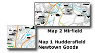 |
You are here:
Map 2 Mirfield
Fieldhouse Bridge - Mirfield Junction
|
|
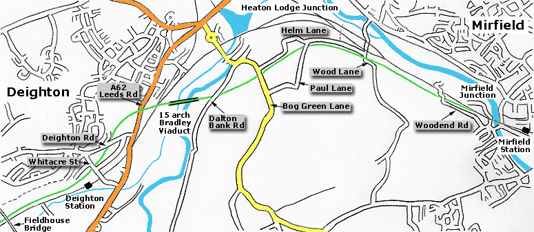 Map 2 Mirfield Map 2 Mirfield
Fieldhouse bridge -
Mirfield Junction
Midland Newtown to Mirfield line shown in green
Existing Huddersfield to
Leeds line & Calder Valley Mainline shown in black.
|
%20%20(08%20to%2023%2007-06-03)%20(24%2008-06-03)/7%20deighton%20rd%20north_small.jpg) Deighton road facing North (01-06-03)
: David Webdale Deighton road facing North (01-06-03)
: David Webdale
A rusty bridge remains carrying Deighton road. The
other side of the bridge the route carries on down toward Leeds road.
Its illuminated by those street lamps, although I can't imagine anyone
using it as a cycle path at night. |
%20%20(08%20to%2023%2007-06-03)%20(24%2008-06-03)/8%20leeds%20rd%20west_small.jpg) Leeds road facing West (07-06-03)
: David Webdale Leeds road facing West (07-06-03)
: David Webdale
The only remaining bits of the bridge over Leeds
road. The section between the pillars remains untouched.
The section to
the right has been made level, originally it sloped upward. |
/lnwr%20crossing%20south%2015-07-06_small.jpg) L
N W R Crossing facing south (15-07-06) : David Webdale L
N W R Crossing facing south (15-07-06) : David Webdale
Remnants of the east side of the bridge crossing the existing
Huddersfield - Dewsbury line.
Note the remaining brickwork at ground level. |
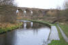
Bradley viaduct
%20%20(08%20to%2023%2007-06-03)%20(24%2008-06-03)/9%20viaduct%2015%20arch%20west_small.jpg) Bradley viaduct facing West (07-06-03)
: David Webdale Bradley viaduct facing West (07-06-03)
: David Webdale
Taken from Dalton Bank road, looking across the
valley towards Deighton. Sixty odd years after the lines closure.
The 15 arch viaduct still looks in good fettle. The embankment leading off toward Mirfield also well preserved. |
/viaduct%20west%2015-07-06_small.jpg) Bradley
viaduct facing west (15-07-06) : David Webdale Bradley
viaduct facing west (15-07-06) : David Webdale
Same view another three years later, squinting into sunlight.
Viaduct & this section of the line now reopened as cycle path.
Note : Nigel Haigh (28-08-14)
On a recent visit to the West Yorkshire Archives,
I did find a couple of documents from the early 1880's relating to sales
of land to the
two railways in the
Heaton Lodge area. To: Midland Railway for the Viaduct over the River
Colne at the Dam Head for £130.
See also London &
North Western Railway section An area of 1 acre, 2 rods, 8 perches
to facilitate widening the railway between Bradley Junction
Station and Heaton Lodge Junction, for £744 and 2 shillings. As I recall
there was a map attached to the details. |
/viaduct%20canal%20east%2015-07-06_small.jpg) Bradley
viaduct facing east (15-07-06) : David Webdale Bradley
viaduct facing east (15-07-06) : David Webdale
Been tidied up beneath the viaduct recently & is much more accessible.
This view looking across the canal. |
/viaduct%20north%20east%2015-07-06_small.jpg) Bradley
viaduct facing north east (15-07-06) : David Webdale Bradley
viaduct facing north east (15-07-06) : David Webdale
View down the other side, from the canal towpath. |
 Bradley
viaduct (26-12-07) : Andrew Stopford Bradley
viaduct (26-12-07) : Andrew Stopford
Seen from the John Ramsden Canal |
/viaduct%20south%20canal%20side%20skew%2015-07-06_small.jpg) Bradley
viaduct facing south (15-07-06) : David Webdale Bradley
viaduct facing south (15-07-06) : David Webdale
Detail of stone springers & skew arch brickwork over the canal to
the right. |
/viaduct%20west%20canal%20side%20skew%2015-07-06_small.jpg) Bradley
viaduct facing west (15-07-06) : David Webdale Bradley
viaduct facing west (15-07-06) : David Webdale
Looking across the canal, carved stone springers & skew arch, nice. |
/viaduct%20river%20east%2015-07-06_small.jpg) Bradley
viaduct facing east (15-07-06) : David Webdale Bradley
viaduct facing east (15-07-06) : David Webdale
A couple of arches crossing the river, see next photo. |
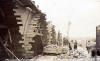
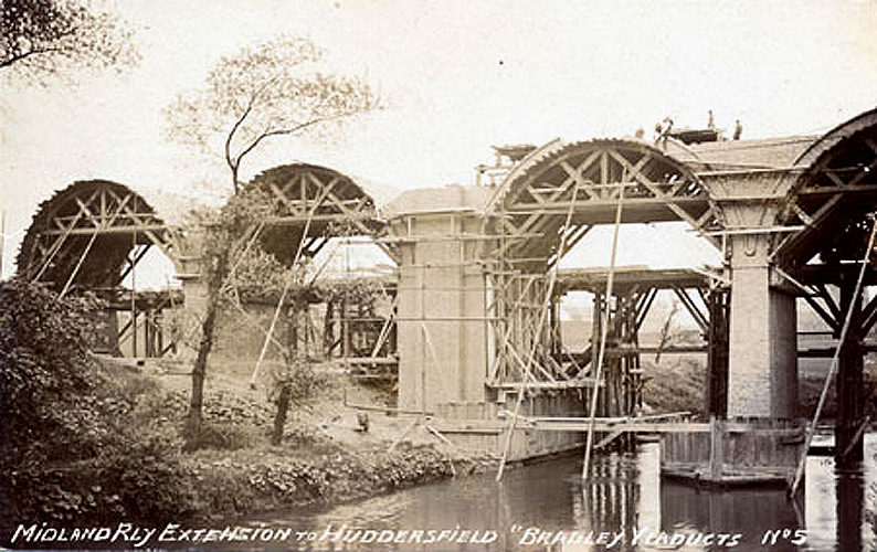
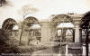 Bradley viaduct under construction (c1902)
Photo Simon Green Bradley viaduct under construction (c1902)
Photo Simon Green
These two photo's Kindly donated by Simon Green, showing
Bradley viaduct under construction.
From a postcard, post dated 1902. Writing says "Midland Rly extension to
Huddersfield Bradley Viaducts No5" |
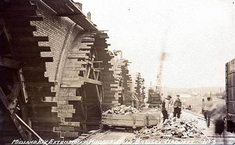
 Bradley viaduct under construction (c1902)
Photo Simon Green Bradley viaduct under construction (c1902)
Photo Simon Green
Writing says "Midland Rly
extension to Huddersfield Bradley Viaducts No3" |
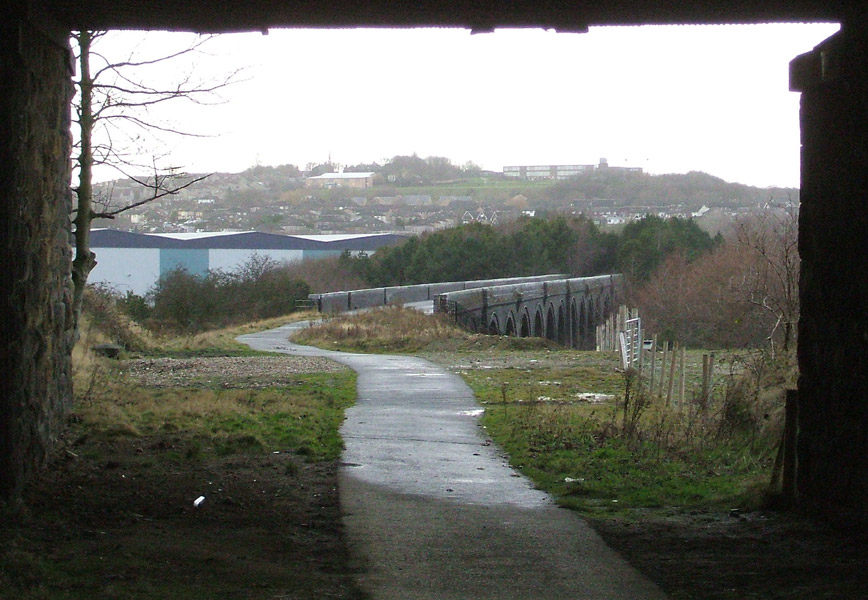
/viaduct%20top%20east%2015-07-06_small.jpg) Bradley
viaduct facing east (15-07-06) : David Webdale Bradley
viaduct facing east (15-07-06) : David Webdale
The view from on top, Dalton bank road in the distance. |
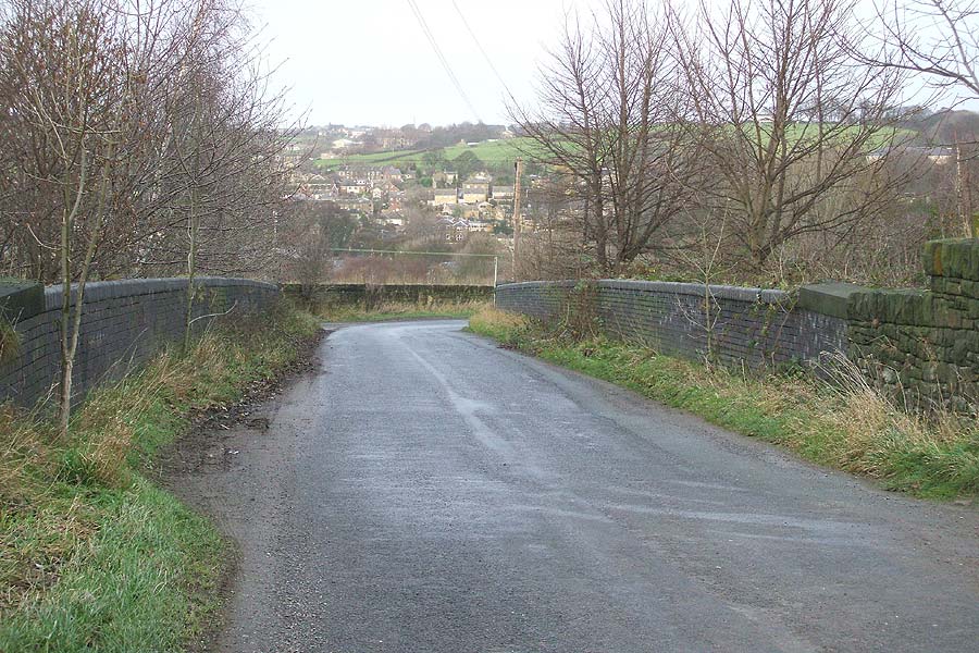
%20%20(08%20to%2023%2007-06-03)%20(24%2008-06-03)/10%20dalton%20bank%20rd%20east_small.jpg) Dalton Bank road facing
east (07-06-03) : David Webdale Dalton Bank road facing
east (07-06-03) : David Webdale
Dalton Bank road bridge, taken from down on the
track bed facing towards Mirfield. |
/dalton%20bank%20rd%20east%2015-07-06_small.jpg) Dalton
Bank road facing east (15-07-06) : David Webdale Dalton
Bank road facing east (15-07-06) : David Webdale
Similar view three years later, note smoke deflectors. |
%20%20(08%20to%2023%2007-06-03)%20(24%2008-06-03)/11%20under%20dalton%20bank%20rd%20west_small.jpg) Under Dalton Bank road facing West (07-06-03)
: David Webdale Under Dalton Bank road facing West (07-06-03)
: David Webdale
Taken from under Dalton Bank road facing back towards the viaduct, just
visible in centre of photo. |
/dalton%20bank%20rd%20west%2015-07-06_small.jpg) Under
Dalton Bank road facing West (15-07-06) : David Webdale Under
Dalton Bank road facing West (15-07-06) : David Webdale
Same view three years later.
|
 Bradley
viaduct (26-12-07) : Andrew Stopford Bradley
viaduct (26-12-07) : Andrew Stopford
Looking at the viaduct towards Huddersfield |
%20%20(08%20to%2023%2007-06-03)%20(24%2008-06-03)/12%20bog%20green%20la%20east_small.jpg) Bog Green lane facing East (07-06-03)
: David Webdale Bog Green lane facing East (07-06-03)
: David Webdale
All filled in along here, only the bridge parapets
remain. Mirfield to the left. |
%20%20(08%20to%2023%2007-06-03)%20(24%2008-06-03)/14%20paul%20la%20north_small.jpg) Paul lane facing North (07-06-03)
: David Webdale Paul lane facing North (07-06-03)
: David Webdale
Same thing here, all filled in underneath &
landscaped. Helm lane is at the far end , Mirfield is to the right. |
 Paul
Lane (26-12-07) : Andrew Stopford Paul
Lane (26-12-07) : Andrew Stopford
Newtown branch underbridge - filled in. |
%20%20(08%20to%2023%2007-06-03)%20(24%2008-06-03)/13%20paul%20la%20cakemoor%20east%20_small.jpg) Paul lane facing East (07-06-03)
: David Webdale -
Info Philip Male Paul lane facing East (07-06-03)
: David Webdale -
Info Philip Male
The bricks in this photo were made at Cakemore Brick Works near Rowley
Regis. If you travel South on the M5 Motorway, between junctions 2 and 3
you will pass the site of where the brickworks was. Shortly after jnc 2,
the motorway dips down to pass under a railway and road bridge. It then
passes under a footbridge. The brickworks was sited immediately left of
that footbridge. A 1902 map of the area, which clearly shows the
brickworks can be obtained from:-
http://www.alangodfreymaps.co.uk/staffs7205.htm
|
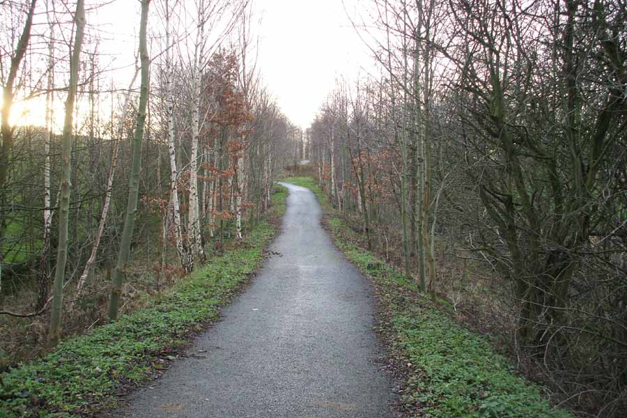
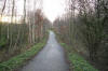 Cycle
path (26-12-07) : Andrew Stopford Cycle
path (26-12-07) : Andrew Stopford
Part of the branch is now used as a cycleway/footpath
(Calder Valley Trail I think) |
%20%20(08%20to%2023%2007-06-03)%20(24%2008-06-03)/15%20wood%20la%20north_small.jpg) Wood lane facing North (07-06-03)
: David Webdale Wood lane facing North (07-06-03)
: David Webdale
A smart looking bridge in good condition. Stone
with a brick arch. A couple more bridges, that look a bit like this one,
are just down & round the corner. They carry the existing Lines from
Heaton lodge junction towards Mirfield. |
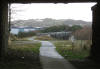
%20%20(08%20to%2023%2007-06-03)%20(24%2008-06-03)/16%20track%20bed%20heaton%20lodge%20east_small.jpg) Track bed near Heaton Lodge facing East (07-06-03)
: David Webdale Track bed near Heaton Lodge facing East (07-06-03)
: David Webdale
A view down the track bed, looking towards Mirfield. Taken from near
Heaton Lodge junction.
The existing lines from Heaton Lodge junction
towards Mirfield are the other side of this earth mound on the left.
The
mill in the distance is seen in close up next photo. |
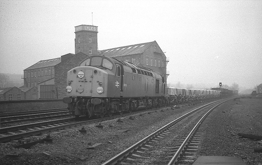
 Class 40 Lyles Mill facing West (c1980)
: David Webdale Class 40 Lyles Mill facing West (c1980)
: David Webdale
A class 40 Freight whistles its way past Mirfield station. I don't know
who the mill in the background belongs to now.
It looked a bit derelict
last time I saw it. |
%20%20(08%20to%2023%2007-06-03)%20(24%2008-06-03)/18%20wood%20end%20rd%20bridge%20west_small.jpg) Woodend
road bridge facing facing West (07-06-03) : David Webdale Woodend
road bridge facing facing West (07-06-03) : David Webdale
Taken from Wood end road. Blue engineering brick this one. I've seen a
few different flavours of bridge on this route. |
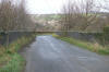
%20%20(08%20to%2023%2007-06-03)%20(24%2008-06-03)/20%20wood%20end%20rd%20west_small.jpg) Mirfield
junction facing West (07-06-03) : David Webdale Mirfield
junction facing West (07-06-03) : David Webdale
Boring, thought I'd better take a photo of where
Mirfield junction was. Woodend road is to the left of picture.
|

%20%20(08%20to%2023%2007-06-03)%20(24%2008-06-03)/7%20deighton%20rd%20north.jpg)
%20%20(08%20to%2023%2007-06-03)%20(24%2008-06-03)/8%20leeds%20rd%20west.jpg)
/lnwr%20crossing%20south%2015-07-06.jpg)
%20%20(08%20to%2023%2007-06-03)%20(24%2008-06-03)/9%20viaduct%2015%20arch%20west.jpg)
/viaduct%20west%2015-07-06.jpg)
/viaduct%20canal%20east%2015-07-06.jpg)
/viaduct%20north%20east%2015-07-06.jpg)

/viaduct%20south%20canal%20side%20skew%2015-07-06.jpg)
/viaduct%20west%20canal%20side%20skew%2015-07-06.jpg)
/viaduct%20river%20east%2015-07-06.jpg)
/viaduct%20top%20east%2015-07-06.jpg)
%20%20(08%20to%2023%2007-06-03)%20(24%2008-06-03)/10%20dalton%20bank%20rd%20east.jpg)
/dalton%20bank%20rd%20east%2015-07-06.jpg)
%20%20(08%20to%2023%2007-06-03)%20(24%2008-06-03)/11%20under%20dalton%20bank%20rd%20west.jpg)
/dalton%20bank%20rd%20west%2015-07-06.jpg)
%20%20(08%20to%2023%2007-06-03)%20(24%2008-06-03)/12%20bog%20green%20la%20east.jpg)
%20%20(08%20to%2023%2007-06-03)%20(24%2008-06-03)/14%20paul%20la%20north.jpg)
%20%20(08%20to%2023%2007-06-03)%20(24%2008-06-03)/13%20paul%20la%20cakemoor%20east%20.jpg)
%20%20(08%20to%2023%2007-06-03)%20(24%2008-06-03)/15%20wood%20la%20north.jpg)
%20%20(08%20to%2023%2007-06-03)%20(24%2008-06-03)/16%20track%20bed%20heaton%20lodge%20east.jpg)
%20%20(08%20to%2023%2007-06-03)%20(24%2008-06-03)/18%20wood%20end%20rd%20bridge%20west.jpg)
%20%20(08%20to%2023%2007-06-03)%20(24%2008-06-03)/20%20wood%20end%20rd%20west.jpg)