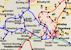
You are here Map 1
Brighouse Anchor Pit junction - Birkhouse
|
Map 1
Brighouse
|
 Anchor
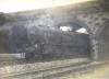
Pit Junction & signal box (19-02-1966) : John Marsh Anchor
Pit Junction & signal box (19-02-1966) : John Marsh
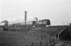
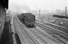
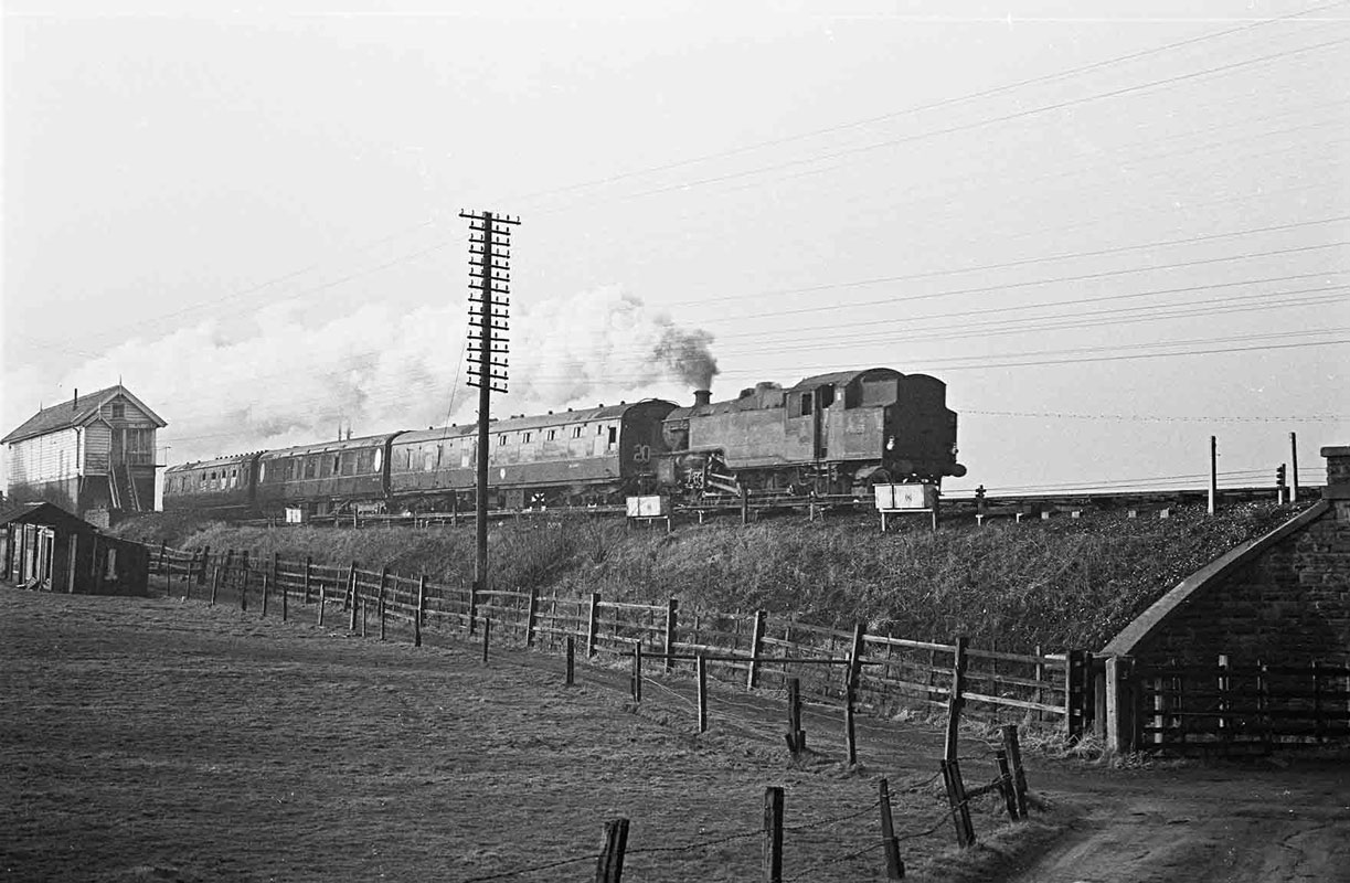
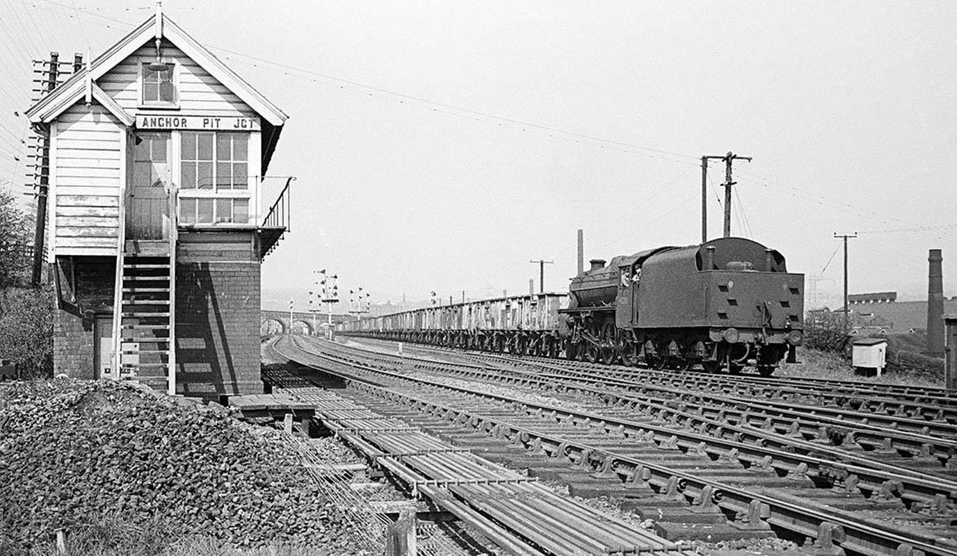
42055 Bradford Exchange to Stockport at
Anchor Pit junction.
The train departed Exchange at 15.20.
see Calder Valley |
 Anchor
Pit junction & signal box (30-04-1966) : John Marsh Anchor
Pit junction & signal box (30-04-1966) : John Marsh
The taken from the veranda of the signal box on
30th April 1966. see also Calder Valley
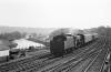
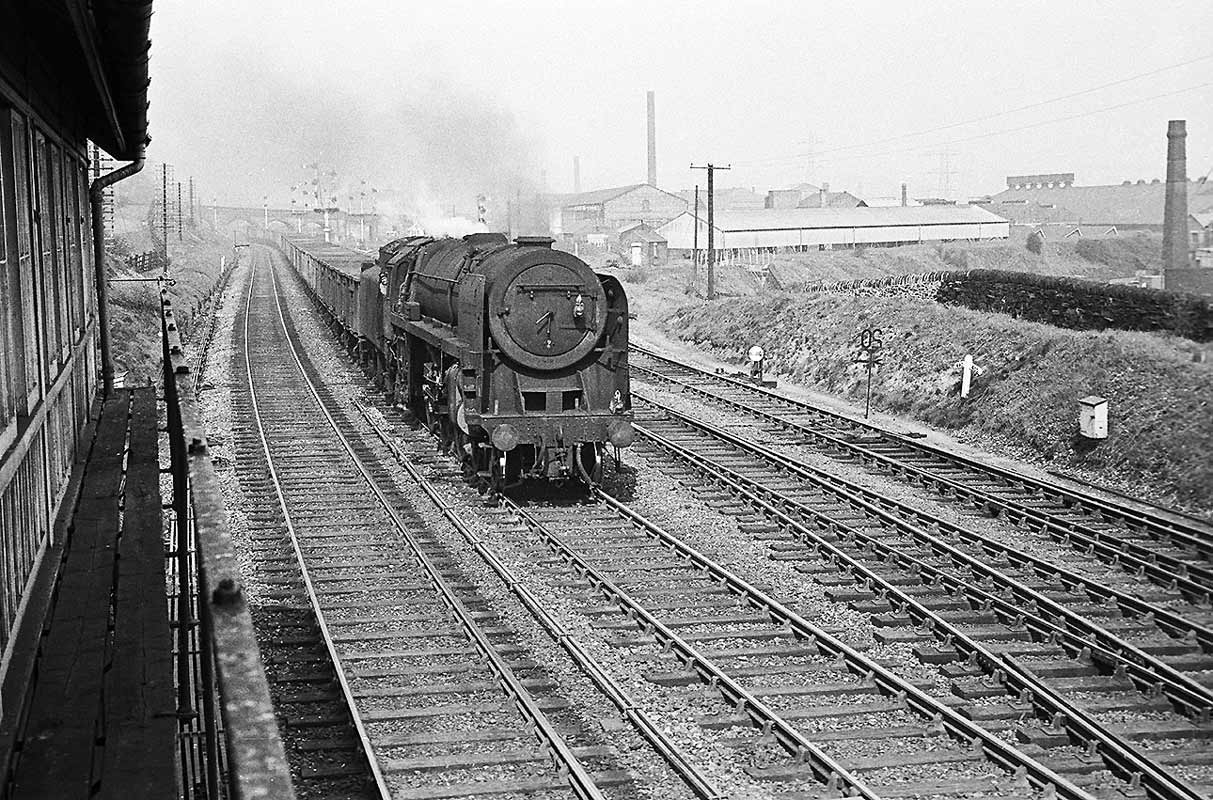
70034 William Wordsworth with coal empties from Lancashire to Healey
Mills.
You can see the track bed of the Pickle Bridge Branch curving off behind
the loco and in front of the white building. |
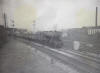
 Anchor
Pit junction & signal box (30-04-1966) : John Marsh Anchor
Pit junction & signal box (30-04-1966) : John Marsh
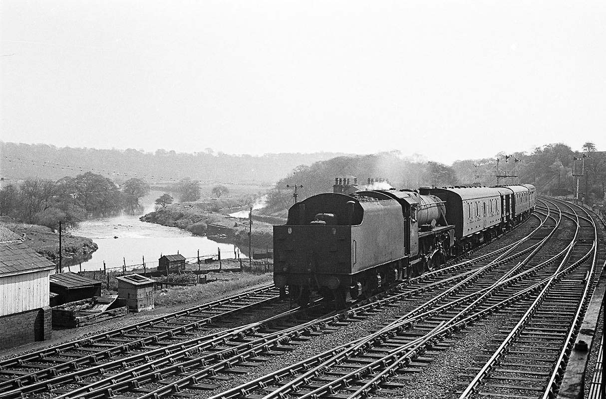
45154 Lanarkshire Yeomanry 11.15 Waklerfield- Bfd
exch parcels at Anchor Pit Junction 30-04-1966. see also Calder Valley |
 Anchor
Pit junction & signal box (30-04-1966) : John Marsh Anchor
Pit junction & signal box (30-04-1966) : John Marsh
45208 Coal empties for Healey Mills at Anchor Pit
Junction 30-04-1966. see also Calder Valley |
  Anchor
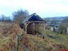
Pit signal box (12-03-08) : David Bradley c/o Graeme Bickerdike Anchor
Pit signal box (12-03-08) : David Bradley c/o Graeme Bickerdike
The old and rather ramshackled signal box from
Anchor Pit Junction.
The remains are on private property, just a short distance from the
box's original location. |
%20(15%20to%2018%20%2023-11-03)%20(19%20to%2024%20%2024-11-03)/15%20anchor%20pit%20junction%20east_small.jpg) Anchor
Pit Junction facing East (25-10-03) David Webdale Anchor
Pit Junction facing East (25-10-03) David Webdale
Taken from Woodhouse lane. (M62 in background)
Anchor pit junction signal box was situated to the right of the multiple
unit.
The Pickle bridge line veered off to the left. From Anchor Pit
junction the gradient over the first mile is about 1 in 60. |
%20(15%20to%2018%20%2023-11-03)%20(19%20to%2024%20%2024-11-03)/11footpath%20west_small.jpg) Footpath
facing west (25-10-03) David Webdale Footpath
facing west (25-10-03) David Webdale
Just behind the building on the left, in above
photo, I found this
overgrown footpath, probably an iron deck bridge crossed here.
|
 Woodhouse
Lane bridge Brighouse : Bernard Coomber Woodhouse
Lane bridge Brighouse : Bernard Coomber
A westbound Austerity with a coal train for
Lancashire passes under Woodhouse Lane bridge Brighouse.
see Calder Valley |
 8F
Brighouse : Bernard Coomber 8F
Brighouse : Bernard Coomber
An eastbound 8F leaving Brighouse with empty
wagons back to the Yorkshire coal fields.
Woodhouse Lane bridge visible in the background.
see Calder Valley |
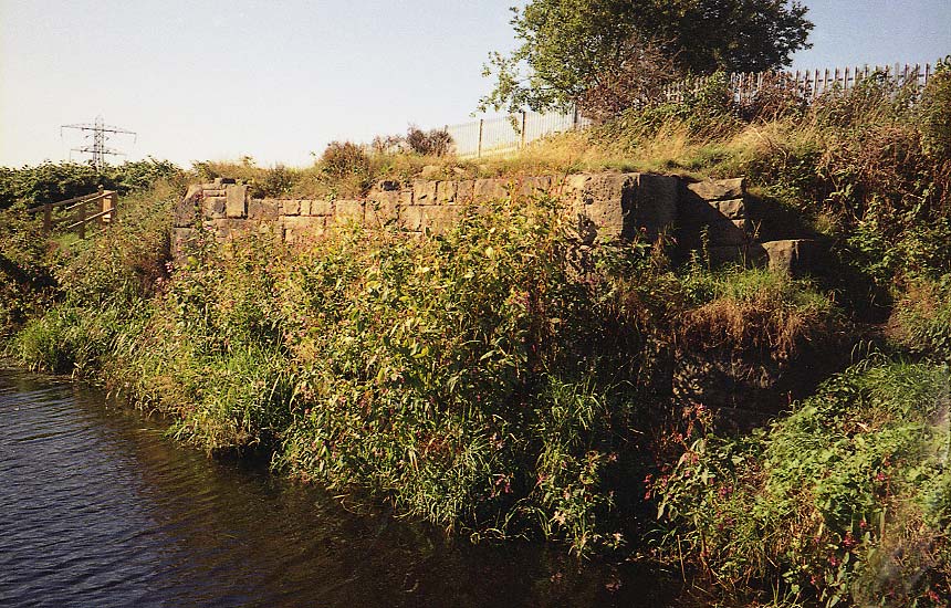
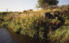 River
Calder facing north west (29-08-05) David Webdale River
Calder facing north west (29-08-05) David Webdale
Photographed from my mates barge. Found this bit
of bridge on the north embankment of the river Calder.
This is the the only bit of evidence I've found in this area. |
%20(15%20to%2018%20%2023-11-03)%20(19%20to%2024%20%2024-11-03)/12%20footpath%20clifton%20west_small.jpg) Footpath
Clifton facing West (25-10-03) David Webdale Footpath
Clifton facing West (25-10-03) David Webdale
No
evidence of bridges over Wakefield road.
The next thing we found was this bridge over a footpath, situated a few
yards from Wakefield road. |
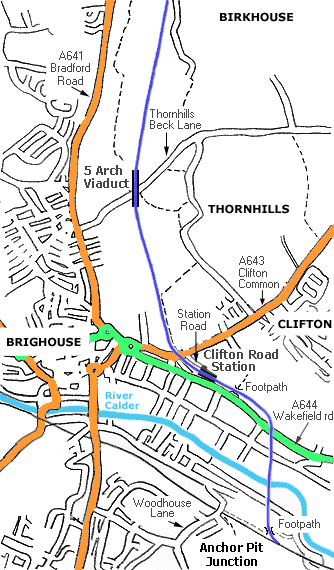
Clifton Road station
Opened 01-03-1881. Closed 14-09-1931. Demolished 1934.
%20(15%20to%2018%20%2023-11-03)%20(19%20to%2024%20%2024-11-03)/13%20clifton%20station%20east_small.jpg) Clifton
Road Station Facing East (25-10-03) David Webdale Clifton
Road Station Facing East (25-10-03) David Webdale
The station was reached via Station road here on the left
behind the gates. Took this photo from Clifton common road.
The Viaduct
crossing here was demolished in the 1970s. |
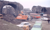 Clifton Road Viaduct Clifton Road Viaduct
See Alf Mullins photo's on flickr -
http://www.flickr.com/photos/49903268@N02/4586635323/in/photostream/ |
%20(15%20to%2018%20%2023-11-03)%20(19%20to%2024%20%2024-11-03)/17%20thornhills%20beck%20north_small.jpg) Thornhills
Beck facing North (23-11-03) David Webdale Thornhills
Beck facing North (23-11-03) David Webdale
Followed the embankment north for a while came
across this massive five arch viaduct spanning Thornhills Beck lane.
Still looks in good nick. This is the view from the embankment. |
%20(15%20to%2018%20%2023-11-03)%20(19%20to%2024%20%2024-11-03)/18%20thornhills%20beck%20east_small.jpg) Thornhills
Beck facing East (23-11-03) David Webdale Thornhills
Beck facing East (23-11-03) David Webdale
View from down on Thornhills beck lane. Bit of
repair work on the parapet.
Apparently someone jumped off this viaduct a while ago. |
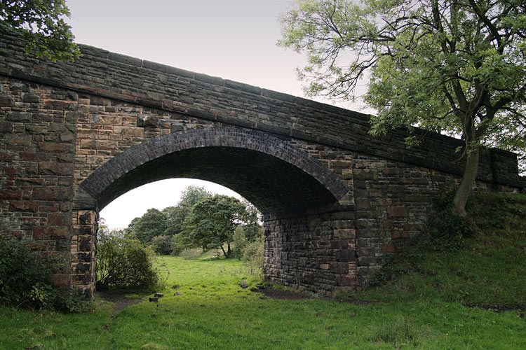
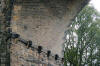 Thornhills
Beck viaduct (09-10-06) Graeme Bickerdike website - http://www.forgottenrelics.co.uk/ Thornhills
Beck viaduct (09-10-06) Graeme Bickerdike website - http://www.forgottenrelics.co.uk/
Close-up of the masonry on Thornhills viaduct. It
never ceases to amaze me how the Victorians dealt so elegantly with
difficult structural problems such as a skew arch, and without any of
the technological advantages of today’s engineers. |
%20(15%20to%2018%20%2023-11-03)%20(19%20to%2024%20%2024-11-03)/16%20thornhills%20beck%20west_small.jpg) Thornhills
Beck facing West (23-11-03) David Webdale Thornhills
Beck facing West (23-11-03) David Webdale
Thornhills beck lane, Looking down toward Bradford
road. |
%20(15%20to%2018%20%2023-11-03)%20(19%20to%2024%20%2024-11-03)/19%20bradford%20road%20east_small.jpg) Bradford
Road facing East (24-11-03) David Webdale Bradford
Road facing East (24-11-03) David Webdale
The view from Bradford road across the valley. |
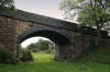 Bridge (09-10-06)
: Graeme Bickerdike Bridge (09-10-06)
: Graeme Bickerdike
A fine accommodation bridge about 300 yards north
of the viaduct. |


%20(15%20to%2018%20%2023-11-03)%20(19%20to%2024%20%2024-11-03)/15%20anchor%20pit%20junction%20east.jpg)
%20(15%20to%2018%20%2023-11-03)%20(19%20to%2024%20%2024-11-03)/11footpath%20west.jpg)

%20(15%20to%2018%20%2023-11-03)%20(19%20to%2024%20%2024-11-03)/12%20footpath%20clifton%20west.jpg)
%20(15%20to%2018%20%2023-11-03)%20(19%20to%2024%20%2024-11-03)/13%20clifton%20station%20east.jpg)
%20(15%20to%2018%20%2023-11-03)%20(19%20to%2024%20%2024-11-03)/17%20thornhills%20beck%20north.jpg)
%20(15%20to%2018%20%2023-11-03)%20(19%20to%2024%20%2024-11-03)/18%20thornhills%20beck%20east.jpg)

%20(15%20to%2018%20%2023-11-03)%20(19%20to%2024%20%2024-11-03)/16%20thornhills%20beck%20west.jpg)
%20(15%20to%2018%20%2023-11-03)%20(19%20to%2024%20%2024-11-03)/19%20bradford%20road%20east.jpg)