|
KIRKLEES
Location/maps used: OS 1:50000 104
Leeds & Bradford; 114 Sheffield & Huddersfield
OS Street Atlas West Yorkshire
|
|
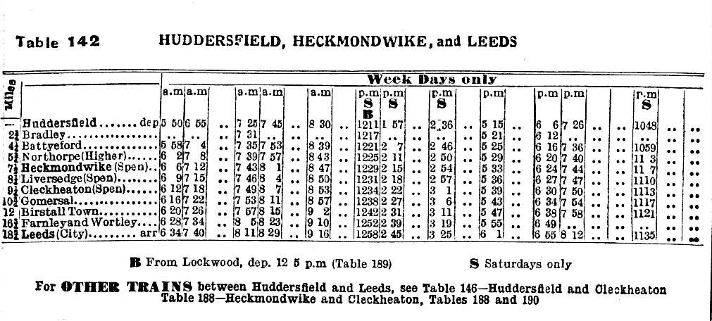
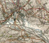
LNWR SPEN
VALLEY JN - LEEDS (FARNLEY BRANCH JN)
(13¼ miles)
(Leeds New Line)
Opened (Gds) 18.9.1899 Spen Valley Jn - Northorpe; Northorpe -
Farnley Jn 9.7.1900
(Pass) 1.10.1900
Closed (Pass) 2.8.1965. (Gds) 11.1.1966 Spen Valley Jn - Farnley;
22.5.1991 Farnley - Farnley Jn stub; 00.10.1997 complete closure.
Stations Heaton Lodge (closed 1864); Battyeford (closed 1953);
Northorpe 1st (burnt down 1921), Northorpe 2nd (opened 1923) r/n 1924
Northorpe Higher (closed 1953); Heckmondwike (Spen); Liversedge (Spen);
Cleckheaton (Spen); Gomersal; Upper Birstall r/n 1935 Birstall Town
(closed 1951); Gildersome East (closed 1921).
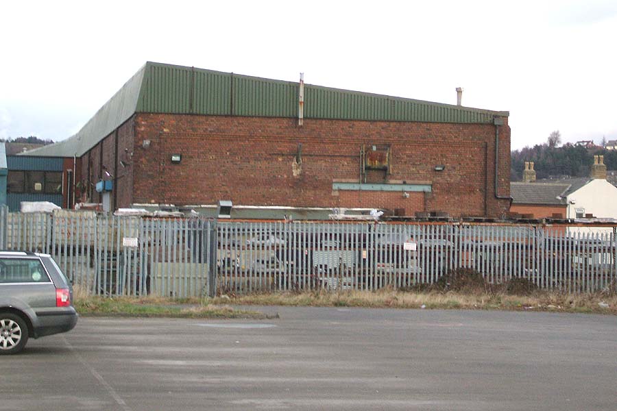
Loco shed Farnley Junction 25G 12-track shed (closed 1966).
History
 Part of the L&NW's original route between Manchester and Leeds utilised
a three mile section of the L&Y's Calder Valley line. In order to
eliminate this bottlemeck and at the same time provide a better service
for Spen Valley towns they opened a second route north of Huddersfield in
1900. Known as the Leeds New Line it closed to passengers in 1965
and all through traffic in 1966. The section of line from Spen Valley
Junction to Heaton Lodge, however, was reopened in 1970, as part of the
major track remodelling, to form an underpass beneath the Calder Valley
main line. Part of the L&NW's original route between Manchester and Leeds utilised
a three mile section of the L&Y's Calder Valley line. In order to
eliminate this bottlemeck and at the same time provide a better service
for Spen Valley towns they opened a second route north of Huddersfield in
1900. Known as the Leeds New Line it closed to passengers in 1965
and all through traffic in 1966. The section of line from Spen Valley
Junction to Heaton Lodge, however, was reopened in 1970, as part of the
major track remodelling, to form an underpass beneath the Calder Valley
main line.
Miniature Railway
The Eddercliffe Light Railway a circuit of mixed 5 ins and 7¼ ins
gauges about 170yds in length has been built on the trackbed at Royds Park
in Cleckheaton (SE200248).
www.spenborough.me.uk
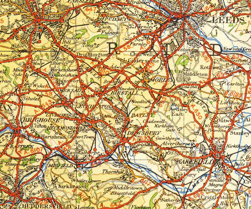
Route when open
 It diverged from the earlier Huddersfield - Dewsbury line at Spen
Valley Junction (SE180205), passed under the L&YR Calder Valley line and
headed east over Battyeford viaduct to Battyeford station. Turning north
it passed from the valley of the Calder to that of the Spen and in quick
succession crossed the L&Y line from Mirfield, the Spen Beck and the L&Y
line from Thornhill to reach Heckmondwike. Now heading NW it passed
through Liversedge and beyond Cleckheaton made a 90° turn to enter
Gomersal tunnel. Emerging from the tunnel it made a long S-bend, passed
under the GNR Batley - Adwalton Jn line and dropped down at 1 in 100
through Gildersome tunnel to join the earlier LNW line from Huddersfield
at Farnley Junction (SE270437). It diverged from the earlier Huddersfield - Dewsbury line at Spen
Valley Junction (SE180205), passed under the L&YR Calder Valley line and
headed east over Battyeford viaduct to Battyeford station. Turning north
it passed from the valley of the Calder to that of the Spen and in quick
succession crossed the L&Y line from Mirfield, the Spen Beck and the L&Y
line from Thornhill to reach Heckmondwike. Now heading NW it passed
through Liversedge and beyond Cleckheaton made a 90° turn to enter
Gomersal tunnel. Emerging from the tunnel it made a long S-bend, passed
under the GNR Batley - Adwalton Jn line and dropped down at 1 in 100
through Gildersome tunnel to join the earlier LNW line from Huddersfield
at Farnley Junction (SE270437).
Route today
The first ¾ mile is still operational, it forms part of the present
down Huddersfield - Leeds line. Housing occupies much of the alignment
from the remains of Battyeford viaduct through Mirfield but some parts to
Northorpe station site are footpaths or access roads. Initially the
embankment north of Still Bank Lane is dense vegetation but soon tracks
and roads follow the alignment as far as Smithies Lane, Heckmondwike from
where public footpaths/streets give access to Walkley Lane and Market
Street. The cutting and site of Heckmondwike Spen station between Market
St (A638) and Cemetery Rd is now occupied by housing but Sustrans have
converted the next section on towards Eddercliffe Crescent at Cleckheaton
into a cyclepath. From there the trackbed is on private land but public
footpaths keep close to the alignment almost to the west portal of
Gomersal tunnel. A path giving access to Oakwell Hall runs along the
embankment east of Dewsbury Rd (A652) beyond which other paths can be
followed almost to the site of Gomersal station. The cavernous Gildersome
tunnel is now no longer accessible but the final section can be followed
either along the trackbed or adjacent rights of way from Rooms Lane (north
of the north portal) to Farnley Junction.
Relics
 Stations Heaton Lodge (on original route) demolished - no
trace; Battyeford demolished - part of viaduct support remains;
Northorpe Higher (on south side of Still Bank Lane) demolished - site
occupied by housing; Northorpe 1st Stations Heaton Lodge (on original route) demolished - no
trace; Battyeford demolished - part of viaduct support remains;
Northorpe Higher (on south side of Still Bank Lane) demolished - site
occupied by housing; Northorpe 1st
(on north side of Still Bank
Lane) no trace; Heckmondwike (Spen) in September 2006 platform
remains bulldozed away for housing; Liversedge (Spen) demolished no
trace; Cleckheaton (Spen) demolished; Gomersal demolished;
Birstall (Town) demolished - site now a factory compound;
Gildersome (East) demolished site returned to agriculture.
Tunnels Heckmondwike station 50yds; Heckmondwike Bridge Street
50yds; Gomersal 819 yds was walkable but in October 2007 the west
portal had 10ft high fencing and the east portal was re-enforced with
rotating razor sharp spikes on the top and anti-climbing paint throughout;
Gildersome 1 mile 571yds, SW portal blocked by M62 spoil, NE portal
bricked up with opening door, three shafts the deepest 190ft..
Bridges Battyeford plate girder bridge 267ft long over River Calder
buttresses and three arches on east bank survive; Battyeford Viaduct
incorporating Battyeford station 18/20 blue brick arches 579ft long over
A644 eleven arches survive; Mirfield Viaduct comprising plate girder span
over Nettleton Road, five arches, plate girder span over Doctor lane and
four arches demolished; plate girder span over Knowle road missing; Plate
girder bridge over Still Bank Lane (site of Northorpe station) buttresses
only; Heckmondwike lattice girder bridge 150 ft long over L&Y Mirfield
branch - some brickwork survives; Heckmondwike Viaduct 240ft long girder
bridge over Spen Beck demolished some brickwork survives; hogback girder
span over L&Y Ravensthorpe branch no trace; Twin span plate girder bridge
carrying Walkley Lane in place; most overbridges in place through
Heckmondwike and Liversedge; Cleckheaton viaduct 450ft long (station
approach road) 60ft high over Mann Dam and Cleckheaton Bottoms 11 spans
supported on cylindrical iron columns in groups of three on blue brick
plinths now closed to road traffic but still used as a footpath; Gomersal
bridge over Dewsbury Rd (A652) one buttress survives.
Loco shed Farnley Junction 25G (SE271312) on west side of line
south of Farnley & Wortley station, demolished 1968. |
|
LNWR BATLEY - BIRSTALL (Single line 2 miles)
(Birstall Branch)
Opened 30.9.1852
Closed (Pass)
1.1.1917; (Gds) 17.6.1962
Stations Carlinghow
(opened 1872), Birstall Lower.
History
The Leeds Dewsbury & Manchester Railway opened
this short branch to Birstall in 1852 with an intermediate stop at
Carlinghow added twenty years later. Wartime economy measures were used
as an excuse to withdraw passenger trains in 1917 but was more down to
the affect of the closely parallel Yorkshire Woolen District trams along
Bradford Road; goods traffic continued until 1962.
Route - when open
A double track junction left the LNW main Dewsbury
- Leeds line at Batley Junction one mile north of Batley station
(GR249244) but became single track almost immediately. It turned NW to
follow close to Bradford Road (A652) with the terminus station at
Birstall (GR225260) located where this road crossed Huddersfield Road
(A62).
Route - today
Much of the branch has been built over but a
footpath follows the course of the line between Carlinghow Hill (the
site of Carlinghow station) and Witton Park.
Relics
Stations - No trace
of Carlinghow; Birstall site cleared and grassed over
Bridges -
northern abutment of bridge over Carlinghow Hill still in situ.
|
|
LNWR
DEIGHTON (KIRKBURTON JN) - KIRKBURTON
(Single line
4¼ miles)
(Kirkburton Branch)
Opened (Pass)
1.10.1867, (Gds 1.1.1968
Closed (Pass)
28.7.1930;
(Gds) 5.4.1965 Deighton ICI - Kirkburton; 1.2.1971
Kirkburton Jn - Deighton ICI.
Stations Deighton
(opened 1871, reopened 1982), Kirkheaton, Fenay Bridge r/n 1897 Fenay
Bridge & Lepton, Kirkburton.
History
When the LNWR built this line they designed the
earthworks capable of taking double track as it was always the intention
to link up with the Midland’s planned line from Barnsley. In the event
the Midland withdrew its Barnsley & Kirkburton proposals and the LNW
were left with a single line branch with the terminus nearer Highburton
than Kirkburton. In the mid-1920s there were as many as twelve trains a
day but the distance from Huddersfield was 6½ miles by rail compared to
4¼ miles by road so that when buses were introduced the railway couldn’t
compete and passenger services (always known locally as Burton Dick)
were withdrawn in 1930. Branches served two collieries, with sidings for
Elliots' Brickworks. The line remained open for freight until 1965 when
it was cut back to the ICI's Dalton chemical works; this huge 250 acre
site had its own self-contained railway system with 20 miles of track,
eight locos and 450 internal rail wagons all served from eight reception
sidings on the branch. When the ICI closed it’s railway there was no
further need for the branch and it closed completely in 1971.
Route - when open
Diverging from the Huddersfield - Leeds line near
Deighton (GR166191) the branch curved across the A62, Sir John Ramsden's
Canal (Huddersfield Broad) and the River Colne before retracing its
steps in a giant loop down the east side of the ? Valley. Beyond the
viaduct it turned south hugging the side of the valley, necessitating a
number of substantial embankments, cuttings and bridges between Nab Hill
and Kirkheaton. After bridging the Huddersfield - Wakefield road (A642)
a colliery line branched off to the east and from Fennay Bridge it
followed Penistone Road (A629) to the Kirkburton terminus (GR191132),
located at the junction of the A629 and North Road.
Route - today
Although not part of the branch the first two
miles of the former Midland Newtown Goods Branch have been converted
into a tarmac cycleway and makes convenient start if commencing the walk
in Huddersfield. It is not possible to walk over Colne Viaduct but
footbridges cross both the canal and river. The route from Colne Viaduct
is at first obliterated by land reclamation. The trackbed emerges and a
good quality footpath continues up to the first road bridge at Nab Hill.
Immediately following the road bridge the cuttings have been filled,
this includes the next road bridge at GR172179. Here it is advised to
take the right of way following the route to the east, as the embankment
is substantially overgrown with the following two road bridges removed.
It is easy to rejoin the emerging trackbed from the site of the south
bridge abutment at Hillside. A ‘dog walk’ continues south but comes to
an abrupt end where industrial units are built on the trackbed. It is
best to leave here as the bridge has been removed over the A642. The
footpath continues on the south side of the main road on a high
embankment above Morrison's Supermarket following which a further bridge
has been removed forcing a return the adjacent footpath. New housing has
been built on the trackbed but it is possible to return to the cutting
that follows. A footbridge survives, it is best to leave by it as
gardens suddenly appear across the old route within a few yards. A
detour onto the A629 Penistone Road is necessary, but a driveway soon
leads back up to a surviving bridge where access can be gained into a
lovely wooded cutting. Sadly this footpath is short-lived and progress
is hindered by yet more house construction across the trackbed.
Following the obstruction, a side road leads from the Penistone Road
back to a missing bridge where access is easy right through to Rowley
Hill and the missing bridge over the main road that links the A629 and
the A642. A path up a grass embankment where the bridge abutment has
been cut back is taken and one of the most continuous and scenic
stretches follows. This includes access to the six arched Rowley
Viaduct, which is substantially overgrown but walkable. The missing
bridge and horse stables force progress off onto the A629 at Highburton.
Here there is no trace of the road bridge that the railway crossed into
Kirkburton Station. The station site is now occupied by houses.
Relics
Stations
Deighton
still open (Huddersfield – Leeds line); no trace of Kirkheaton or Fenay
Bridge & Lepton; Kirkburton demolished - site occupied by housing but a
massive stone wall survives.
Bridges
Colne
viaduct at Deighton seven brick arches over the A62, Sir John Ramsden
Canal (Huddersfield Broad) and the River Colne constructed on a curve
with a radius of 484yds still stands but substantially fenced on the
western approach.
Rowley viaduct six brick arches over Beldon Brook
at Dogley Lane in place.
The only road overbridge bridge that survives is the first one at Nab
Hill.
A further bridge carrying a track is at
GR184153.
Several under bridges carrying over streams and tracks
survive.
Misc.
Rails of the
branch into the ICI chemical works at Dalton, can still be seen; several
fine examples of original boundary stones, inscribed with the legend "L&NWR"
at Beldon Brook.
|
|
L&YR
MIRFIELD No 3 - LOW MOOR
(6½ miles)
(Spen Valley Line)
THORNHILL No. 1 - HECKMONDWIKE
(2miles 331yds)
LOW MOOR No 5 - LOW MOOR No 1
(508yds)
(Low Moor Fork)
Opened Mirfield -
Low Moor 18.7.1848
Thornhill - Heckmondwike (Gds) 10.5.1869, (Pass)
1.6.1869
Low Moor Fork 22.4.1886
Closed (Pass)
14.6.1965
(Gds) Mirfield - Heckmondwike 14.6.1965;
Heckmondwike - Low Moor 1981
Thornhill Jn - Liversedge Spen (LNW) (Via a 1966
spur L&Y to LNW) OOU Sept. 1990
South Curve (Pass) 1.1.1962, (Gds) 19.1.1970
Stations Northorpe
North Road (Opened 1891), Heckmondwike (Central), Liversedge (Central),
Cleckheaton (Central), Low Moor; Ravensthorpe Lower (opened 1869 closed
1952).
Signal boxes
Mirfield No 3, Mirfield No 4, Heckmondwike Junction, Liversedge,
Cleckheaton North, Ellisons Siding, Low Moor No 5, Low Moor No 5, 2 and
1.
Loco shed Low Moor
25F twelve-track shed (closed 1967)
History
The branch was closed between 1970 -74 for
construction of the M62 and permanently between Mirfield and Low Moor in
1981 with the southern end remaining in use to Liversedge oil terminal
until 1990 The northern end of the route was intended to become part of
the new Transperience Centre at Low Moor until it ran into
serious financial difficulties.
Reopeing
proposal
In 1998 a group called Missing Link
announced that they were developing a case for a light rail link from
Dewsbury to Bradford that would utilise the route between Thornhill and
Low Moor with street running in the town centres. In November 2001 an
area rail user group was set up to press for reopening of the line to
serve Cleckheaton.
Route - when open
The junction at Thornhill No 3 (GR235201) was
alongside the Calder Navigation and it was here that this branch
diverged NE from the L&Ys’ Wakefield - Sowerby Bridge line. In quick
succession it passed under the line to Dewsbury, over the River Calder
by a 12 arch viaduct and Huddersfield Road (A644) to reach Ravensthorpe
Lower. It then continued north alongside the River Spen to join the leg
from Mirfield at Heckmondwike. The western leg diverged NE from the
Wakefield - Sowerby Bridge line at Mirfield No 3 (GR207194), crossed the
Calder and passed under Huddersfield Road to reach Northorpe North Road
station. Now heading north it passed under the LNWs’ Spen Valley line
and joined the other leg at Heckmondwike Junction. For the final 4½
miles it followed the Spen Valley and Bradford Road (A638) NW with the
stations at Heckmondwike, Liversedge and Cleckheaton coming within the
first two miles. At Oakenshaw it turned west and a short tunnel took it
under Wyke Lane from where it reached the triangular junction at Low
Moor and Low Moor station (GR165283) on Cleckheaton Road (A650).
Route - today
Sustrans have converted the full route into a
cycleway the Spen Valley Greenway. It was officially opened on 4
May 2001 by Sir John Harman, Chairman of the Environment Agency. The M62
is crossed by means of a footbridge and the trail ends at Oakenshaw. The
Spen Valley Greenway will eventually run from Thornhill Lees to
Bradford, Shipley and Saltaire
Relics
Stations - any trace
of Northorpe North Road? Heckmondwike (Central) long
platform survives; Liversedge (Central) no trace; Cleckheaton
(Central) demolished site occupied by a supermarket; Low Moor
demolished.
Bridges - most
bridges intact including twelve arch stone viaduct over River Calder;
new footbridge over M62 north of Cleckheaton
Tunnels - Littletown
79yds part of trail; Oakenshaw tunnel 67yds part of trail.
Loco shed Low Moor
(SE166284) on west side of Low Moor station, demolished 1976.
|
|
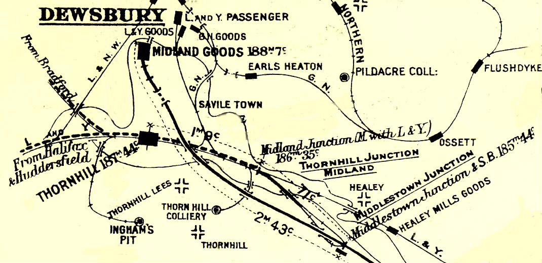
L&YR
DEWSBURY EAST JN - DEWSBURY MARKET PLACE
(1¼ miles)
CURVE FROM HEADFIELD JN - DEWSBURY WEST JN
(¼ mile)
Opened (Gds)
27.1866, (Pass) 1.4.1867
Closed (Pass)
1.12.1930,
(Gds) 6.2.1961 (re-opened East Jn - Headfield Jn
1.12.1965); 00.7.95 Blue Circle - Railway Street Yard
Stations Dewsbury
(Market Place)
Signal boxes
Dewsbury West Junction, Dewsbury East Junction, Headfield Junction, Mill
Street Crossing.
History
In 1861 the LNW would not agree to the L&Y running
into Dewsbury Wellington Road station so plans for a separate branch to
the town went ahead and this short double track branch opened in 1866.
It closed in 1961 only to re-open four years later to Headfield Junction
and thence to Dewsbury Junction and Railway Street goods depot when the
ex-GN route to Dewsbury closed completely in 1965. In 1969
Blue Circle Cement opened a depot on the site of the ex L&Y Dewsbury
Junction Carriage & Wagon Works and this too was served from Headfield
Junction.
Route - when open
It commenced from a triangular junction with the
L&Ys Mirfield - Normanton line. From Dewsbury East Junction (GR251198)
it curved north to cross the Long Cut of the Calder & Hebble Navigation.
At North Junction a spur came in from West Junction completing the
triangle and at Headfield Junction the spur to the GNR diverged NE and
bridged the River Calder. After crossing a single span bridge over the
River Calder the branch ended at Market Place which had a covered island
platform with an extensive goods yard.
Route - today
Part of the branch is still in use and soon after
leaving Dewsbury East Junction it becomes double track. Just before the
stone three-arched Bretton Street bridge the third side of the one-time
triangular junction trails in, now realigned as sidings for the Blue
Circle cement works which sees daily trains from Earles Cement works in
the Hope Valley. The works yard access road crosses the sidings adjacent
to the junction protected by hand-worked lifting barriers. At this point
Tilcon have a stacking area with stone unloaded from one of the running
lines. The double track ends just before a disused overbridge, and the
line ends with a single track headshunt. As far as this point the line
has been part of the L&Y branch but the headshunt is actually on the ex-GN
formation curving NE through the right-hand girder decked span of the
bridge. The Market Street line continued straight on through the
left-hand stone arch which is now minus any parapets. This branch now
ends at buffers stops a few yards beyond the former Headfield Junction.
Ballast continues across Mill Street East underbridge No 4, the curving
two-span, skew girder bridge across the River Calder and the lengthy
stone viaduct beyond which curves round almost to site of the trailing
connection at Dewsbury Junction with the line from Earlsheaton tunnel.
Relics
Stations - Market
Place terminal passenger station (closed in 1930) is now occupied by
a raised flower bed area whilst the extensive goods yard with four
warehouses (closed in 1961) is now a sports centre and car park.
Bridges -
single span bow shaped wrought iron bridge 135ft long 12ft high over
Calder into Market Place demolished. The double span skew
bowstring girder bridge over the Calder and lengthy stone viaduct on the
ex-GNR Headfield Jn - Dewsbury Jn line is still intact but fenced off at
both ends.
|
|
L&YR
MELTHAM JN (LOCKWOOD) - MELTHAM
(single line
3½ miles)
(Meltham Branch)
Opened 5.7.1869
Closed (Pass)
23.5.1949, (Gds) 5.4.1965
Stations Woodfield
(opened/closed June 1874), Netherton, Healey House,
Meltham Mills (workers), Meltham
Loco shed Meltham
one-track shed (closed late 1889)
History
Although line was authorised in 1861 work did not
start until 1865 and because of major landslips it was August 1868
before the line opened for goods traffic. This only lasted three weeks
as further slips occurred requiring massive earthworks to be constructed
at the two most troublesome locations. The line finally opened for both
passenger and goods trains in July 1969. Woodfield station was only open
one month in June 1874; its name was to have been Dungeon Wood (such a
name-board was actually erected) but the name was changed to Woodfield
before opening.
Route - when opened
The branch left the Huddersfield Penistone line
just before the north end of Lockwood viaduct (GR133149) and headed
south west up the opposite side of the Holme Valley. After passing
through two tunnels it followed the valley of Hall Dyke through a deep
cutting at Hall Heys and crossed the B6108 to reach the terminus at
Meltham (GR100108). The single platform station located in Station Road
(B6107) was at a much higher level than the large goods yard.
Route - today
The trackbed can be walked from Meltham Junction
(under Hanson Lane bridge), passing Woodfield station and crossing a
bridge over a wide path leading to the arched entrance of Beaumont Park.
Some of the party managed to get into Butternab tunnel but, not only
is the south portal blocked, it is in the private garden of a number of
houses built on the trackbed, the embankment having been partially
removed north of Butternab Ridge underbridge. The next section,
including the stone arch over Nethermoor Road, is intact but
inaccessible. Both portals of Netherton tunnel have been bricked
up but having gained permission from a farmer the party were able
pass through his farmyard (the site of Netherton station) to walk
through the stalactite hung Netherton tunnel. For those not able to walk
the tunnel its approximate line is followed above ground by the
appropriately named Tunnel Street and the trackbed can be regained at a
tall occupation underbridge at GR117124 and followed southwards through
the site of Healey House station and the 30yd tunnel. The next stretch,
including the site of Netherfield station, is inaccessible although its
south end can be reached by walking back from Huddersfield Road, north
of Meltham Mills. The skew bridge across this road was completely
demolished soon after the line closed and the embankment cut back on
both sides but from here to Meltham the line can be walked without
difficulty. Two underbridges of different styles precede the wooden
footbridge on the north side of which was the private Meltham Mills
Halt; this unadvertised station served the Union Thread Mills of J & P
Coates, later taken over by David Brown for tractor construction.
In March 1999 it was reported that this site is to be used for Safeway
supermarket and as a result two footbridges will be removed and the
footpath diverted.
Relics
Stations -
Woodfield platform edge; Netherton station site now a farm;
Healey House no trace, Meltham Mills no trace; the site of
Meltham is an empty wasteland but the station house in Station
Street is a residence.
Tunnels - Butternab
north portal bricked up, south portal bricked up with door; Netherton
333yds north portal bricked up, south portal bricked up with door;
Healey House 30yds walkable.
Bridges - most
bridges intact; abutments only of bridge at Healey House; bridge over
Huddersfield Road (B6108) demolished 1966
Loco shed Meltham
(SE101108) on north side of line at east end of Meltham station.
|
|
L&YR
BROCKHOLES JN - HOLMFIRTH
(1¾ mile)
(Holmfirth Branch)
Opened 1.7.1850,
closed 3.12.1865, reopened 11.3.1867
Closed (Pass)
2.11.1959; (Gds) 3.5.1965
Stations
Thongsbridge, Holmfirth
Signal boxes
Brockholes Junction, Thongs Bridge, Holmfirth
History
This branch was opened by the Huddersfield &
Sheffield Junction Railway on the same day as it opened its main line.
It was built double track throughout as the L&Y planned to extend the
line Holmbridge further up the Holme Valley.
Route - when open
From a junction near Brockholes station (GR155104)
on the Huddersfield - Penistone line, the line headed south in a gentle
curve and on a falling gradient of 1 in 100 crossing Mytholmbridge
viaduct before reaching the intermediate station at Thongsbridge. The
line then climbed at 1 in 120 for one mile to reach the terminus station
at Homfirth (GR144098) located in Station Road (A635).
Route - today
Detail of exactly which sections are walkable
required
Relics
Stations -
Thongsbridge demolished site occupied by housing; Holmfirth
station site now occupied by Kingdom Hall, Station Master’s house 'To
Let' March 2002.
Bridges -
Mytholmbridge Viaduct 13 curved arches, demolished
1976, abutments survive.
|
|
L&YR
CLAYTON WEST JN - CLAYTON WEST
(single line
3¼ miles)
(Clayton West Branch)
Opened 1.9.1879
Closed 24.1.1983
Stations
Skelmanthorpe, Clayton West
Signal boxes Clayton
West Junction, Skelmanthorpe, Clayton West
History
When the L&Y opened this single line branch they
built it to double width as they planned to extend the line to Darton on
their Wakefield - Barnsley line.
Narrow Gauge Railway
After closure the line was purchased privately and
a 15ins-gauge steam railway built on the trackbed. The Kirklees Light
Railway opened in 1991 and comprises four steam locos, a diesel shunter,
a petrol engined tram engine, ten coaches, four stations, a cafe and
shop, engine shed, workshop and two turntables. All the engines have
been hand-built by the proprietor Brian Taylor.
Route - when open
At Clayton West Junction (GR208101) the line
diverged NE from the Huddersfield - Penistone line, crossed a minor road
and entered Shelley Woodhouse tunnel. Emerging from the tunnel it turned
east, passed Skelmanthorpe station and after a further two miles bridged
Wakefield Road (A636) to reach the terminus station at Clayton West
(GR259113).
Route - today
The Kirklees Light Railway has been built on the
trackbed for the full length of the branch.
Relics
Stations on the closed line
?Skelmanthorpe; Clayton West the station buildings were
considered uneconomic to restore and were demolished in 2000; a new loco
and rolling stock shed now occupies the site. Railway Court, a
housing development has been built across the station's former entrance.
New stations on the n.g. line
- Shelley, Skelmanthorpe, Cuckoo's Nest
Halt, Clayton West
Tunnels -
Shelley Woodhouse tunnel 511yds in use.
Signalling Clayton
West Junction signal box was damaged by fire but parts were retained and
incorporated into a five bedroom house nearby, in August 2004 it was on
the market for £325,000.
|
|
GNR
WRENTHORPE SOUTH JN (WAKEFIELD)
- BATLEY - ADWALTON JN (7¼ miles)
WRENTHORPE NORTH
JN - WRENTHORPE WEST JN (West Curve) (748yds)
Opened
7.4.1862 Wrenthorpe South Jn - Flushdyke; 15.12.1864 Flushdyke - Batley;
1.8.1864 Batley - Adwalton Jn; Wrenthorpe West Curve (Gds) 7.9.1864,
(Pass) 15.2.1865.
Closed 7.9.1964 (Pass), 1.5.1972 (Gds). Wrenthorpe West Curve (Pass)
Oct 1938, (Gds) 1.11.1965
Stations Alverthorpe (opened 1872 closed 1954), Ossett r/n 1864
Flushdyke (closed 1941), Ossett, Chickenley Heath (opened 1877 closed
1909), Batley (1st), Upper Batley (closed 1952), Howden Clough (closed
1952).
History
The Bradford,
Wakefield & Leeds Railway (BW&LR) opened this line in stages between
1862 and 1864. Before it was fully opened the BW&LR changed its name to
the West Yorkshire Railway which was in turn was absorbed in 1865 (along
with the direct Wakefield - Leeds line) by the expanding GNR. An early
casualty brought about by the more convenient electric trams was the
passenger service to Chickenley Heath, known locally as the
Chickenley Coddy; it closed in 1909.
Route - when open
 The
line diverged west from the Doncaster - Leeds line at Balne Lane signal
box three quarters of a mile north of Wakefield Westgate station
(SE323217), making a 90° turn, with Wrenthorpe yard to the north, before
heading SW to the first station at Alverthorpe. The next station, was
originally named Ossett but changed to Flushdyke when the line was
extended and a new Ossett station opened in the town centre. At
Runtlings Lane Junction it became a single line which left the Dewsbury
line and curved north, entered Ossett tunnel and passed under Wakefield
Road (A638) to reach Chickenley Heath station. After a further mile Shaw
Cross tunnel took it under Leeds Road (A653) from where it curved west
to pass through Batley GN station where a complex series of junctions
gave access to its own lines to Leeds, Bradford and Dewsbury and the LNW
lines. North of Batley the GN line to Leeds diverged on the right whilst
this line bridged the LNW line and continued north to Upper Batley. At
Howden Clough it bridged the LNW ‘New Line’ and after passing under the
A62 swung west to join the main Wakefield - Bradford line at Adwalton
Junction (SE228279). The
line diverged west from the Doncaster - Leeds line at Balne Lane signal
box three quarters of a mile north of Wakefield Westgate station
(SE323217), making a 90° turn, with Wrenthorpe yard to the north, before
heading SW to the first station at Alverthorpe. The next station, was
originally named Ossett but changed to Flushdyke when the line was
extended and a new Ossett station opened in the town centre. At
Runtlings Lane Junction it became a single line which left the Dewsbury
line and curved north, entered Ossett tunnel and passed under Wakefield
Road (A638) to reach Chickenley Heath station. After a further mile Shaw
Cross tunnel took it under Leeds Road (A653) from where it curved west
to pass through Batley GN station where a complex series of junctions
gave access to its own lines to Leeds, Bradford and Dewsbury and the LNW
lines. North of Batley the GN line to Leeds diverged on the right whilst
this line bridged the LNW line and continued north to Upper Batley. At
Howden Clough it bridged the LNW ‘New Line’ and after passing under the
A62 swung west to join the main Wakefield - Bradford line at Adwalton
Junction (SE228279).
Route - today
Although the
embankment has been removed paths follow the alignment west from
Wrenthorpe South and North Junctions to the site of Alverthorpe station
(SE313214). From Flanshaw Lane the course can still be traced to
Roundwood Junction where the line is cut by the M1 but west of the
motorway all trace has disappeared under development. A short section on
the approach to Runtlings Lane remains (although infilled) and it is
possible to walk the whole length from Runtlings Lane Junction to
Wakefield Road A638 at Chickenley Heath. Ram stadium has been built over
the alignment at Shaw Cross whilst north of Leeds Road a short section
has been used for Challenge Way an extension of the B6128. Parts
of the alignment are still in place between the A653 at Shaw Cross and
Batley and between Batley and Adwalton Junction but little remains
walkable.
Relics
Stations
Alverthorpe demolished - site landscaped; Flushdyke
demolished - no trace; Ossett demolished - site occupied by
housing in Southdale Gardens but station house survives; Chickenley
Heath demolished; Batley still open on ex LNW line; Upper
Batley modern station house residence; Howden Clough
demolished - site built over.
Bridges Wrenthorpe
- Batley plate girder bridge over Wakefield Road in Flushdyke
removed 1966; in Ossett viaduct over Towngate missing; Station Road
overbridge infilled; plate girder bridge over Queen Street abutment
only; bridge carrying minor road approaching Batley survives.
Bridges Batley -
Adwalton Jn girder bridge over LNW line at Lady Ann Crossing
abutments only; bridge carrying the footpath extension of Sunnbank Rd
survives; bridge over Timothy Lane missing; at Howden Clough bridge over
Scotchman Lane missing; bridge carrying A62 Gelderd Rd parapet
Tunnels
Chickenley Heath 47yds filled in and landscaped; Shaw Cross 209yds under
Leeds Road both portals earthed over.
|
GNR OSSETT
(runtlIngs lane jn) - BATLEY
(3½ miles)
GNR OSSETT (RUNTLINGS LANE JN) - BATLEY (3½ miles)
(Dewsbury Loop)
GNR DEWSBURY SOUTH JN - HEADFIELD JN (¾ mile)
Opened
Runtlings Lane - Dewsbury Jn (Gds) 1.5.1874, (Pass) 9.9.1874.
Dewsbury Jn - Batley 12.4.1880. 1877 Headfield Jn - Dewsbury South Jn.
Closed
(Pass) 7.9.1964, (Gds) 15.2.1965. re-opened East Jn - Headfield Jn
1.12.1965; finally closed ?date. (Gds) 3.5.1960 Headfield Jn - Dewsbury
South Jn.
Stations
Earlsheaton (opened 1875 closed 1953), Dewsbury (renamed Dewsbury
Central 1951), Batley Carr (closed 1950), Batley GNR..
History
The GNR had opened a direct line from Wakefield to Batley in 1864 and this
line, opened ten years later, formed a loop that took in Dewsbury. The
direct route was then downgraded and the Dewsbury line became one of three
routes by which portions of Kings Cross expresses travelled to and from
Bradford. In 1933 the LNER closed the short branch from Dewsbury Junction to
the GN goods depot in Railway Street and lifted the track. In 1965 the track
was reinstated by BR to provide access to the Railway Street goods depot
from the ex-L&Y line when the GN route to Dewsbury closed. The GN goods
depot subsequently closed and in 1995 the track was again lifted this time
back to the canal bridge.
Route - when open
From Runtlings Lane Junction (SE273201) the line curved NW then west and
after one mile reached Earlsheaton station. Earlsheaton tunnel then carried
it under Headland Lane and Middle Road. Leaving the tunnel it turned north
and at Dewsbury Junction (SE251211) there were two branches; one branch went
NW into the GN Railway Street goods yard whilst the other, making a trailing
connection from the south, was a spur from Headfield Junction. North of
Dewsbury Junction a short tunnel took it under Wakefield Road and Leeds Road
to Dewsbury Central station and from there, on a gradient of 1 in 53,
Crackenedge tunnel took it under the LNWR line to reach Batley Carr station
located in a brick cutting. The line was then carried on a ledge (parallel
to but at a lower level than the LNW route), towards Batley. Just before
Batley station it passed below the LNW once more and over a viaduct
(adjacent to the LNW viaduct) into its own island platform at Batley GNR
station (SE250250).
Route - today
A path leads away from Runtlings Lane Junction and picks up the trackbed
after half a mile. On both sides of Earlsheaton station site one mile has
been utilised for the Kirklees Way with a short detour around Earlsheaton
tunnel. Kirklees Way continues along the track bed north to Ridings Road and
Wakefield Road A638. North of Batley a long high brick retaining wall
survives at Jack Lane but little else remains between Batley Carr and
Batley. The whole of the spur from Dewsbury Jn - Headfield Jn, including the
bridges, is walkable.
Relics
Stations
Earlsheaton demolished - site unused; Railway Street goods yard now
occupied by Sainsbury’s and other retail units;
Dewsbury Central the
elevated site overbuilt by the northern inner ring road but the street level
facade of the station entrance has been preserved.
Batley Carr site is
occupied by an auto salvage depot;
Batley GNR?
Tunnels
Earlsheaton 179yds intact but sealed at both ends; Leeds Road 213yds
opened out during ring road construction but top of south portal survives;
Batley Carr aka Crackenedge 171yds south portal earthed over, north portal
open but in scrap yard, red brick ventilation shaft survives.
Bridges
On the main line in Dewsbury bridge over Crackenedge Lane removed
but abutments used for Ring Road; Batley Carr a long straight plate girder
bridge takes Wood Lane over the line but further north Jack Lane overbridge
has been demolished; approaching Batley the bridge under the LNW has been
infilled; Batley Viaduct comprising plate girder span, five masonry arches,
steel span and one arch, dismantled - no trace.
On the spur Dewsbury Jn - Headfield Junction Headfield Viaduct over
River Calder comprising, 13 masonry arches over the flood plain.
A plate
girder span over Sands Lane and two bowstring spans of 110ft and 126ft over
the river in place;
single 88ft span bowstring bridge over Dewsbury cut of
the Calder & Hebble Navigation in place; plate girder bridge over Mill
Street East in place;
Two-arch masonry and single span girder bridge
carrying Thornhill Street at Headfield Junction in place.
|
|
MR
MIDDLESTOWN JN - DEWSBURY (SAVILLE TOWN)
(2½ miles)
(Saville Town Goods Branch)
Opened 1.3.1906
Closed 18.12.1950
Stations Saville Town Goods
Signal boxes Middlestown Junction
History
This branch was originally going to be part of the companies
alternative main line to Bradford and Scotland but ended up as a dead-end
goods branch to Dewsbury. The Midland reached Middlestown Junction from
Royston Jn in November 1905 and four months later completed this short
goods only branch into Dewsbury. It was closed by BR at the end of 1950.
Route - when open
  From Middlestown Junction (SE267186) the line headed NW to cross the
L&Y at Headfield Road on a long through girder bridge and beyond there the
‘main line’ became a siding which terminated on an embankment just
short of Saville Road. The goods branch dropped down at 1 in 40 into a
cutting which passed beneath Saville Road in a tunnel to the Saville Town
Yard (SE242213) which was quite extensive. From Middlestown Junction (SE267186) the line headed NW to cross the
L&Y at Headfield Road on a long through girder bridge and beyond there the
‘main line’ became a siding which terminated on an embankment just
short of Saville Road. The goods branch dropped down at 1 in 40 into a
cutting which passed beneath Saville Road in a tunnel to the Saville Town
Yard (SE242213) which was quite extensive.
Route - today
The first half mile is walkable but a detour is then required via
Kirklees Way to Combs and the B6117 to Headfield Road. The site of three
sidings to the south of Dewsbury Goods Junction is now a playing field and
that leads to an aptly named road 'The Sidings.' Crossing Saville Road
then gives access to the north portal of Saville Road tunnel but further
progress is barred by industrial buildings.
Relics
  Stations Saville Town goods yard site now sees light
industrial use, brick built goods warehouse converted. Stations Saville Town goods yard site now sees light
industrial use, brick built goods warehouse converted.
Bridges supporting walls of dive under survive; three-arch viaduct
over Calder Hebble Navigation in place; long girder bridge spanning
Headfield Road and L&Y line (at Dewsbury West Jn) buttresses only.
Tunnels Saville Road tunnel 187yds long- cutting and tunnel
infilled 1998 but north end of tunnel can still be seen.
|
|
MR
MIRFIELD JN - HUDDERSFIELD (NEWTOWN GOODS)
(4½ miles)
Opened 1.11.1910
Mirfield Jn - Newton Goods; 1.10.1923 connection from the LNW line at
Red Doles Jn
Closed 12.8.1937
Mirfield Jn - Spur from Red Doles Jn; 5.8.1968 Red Doles Jn -
Huddersfield (Newtown)
Stations Newtown
Goods
History
To gain a presence in Huddersfield the Midland
opened a goods only branch in 1910 from the Calder Valley line at
Mirfield. Most of the branch closed in 1937 but access to Newtown Goods
was maintained by a connecting spur from the ex-LNWR Leeds -
Huddersfield line at a new Red Doles Junction. This section of the
branch finally closed in 1968.
Route - when open
It diverged from the Leeds - Huddersfield line at
Mirfield Junction (GR199197) approx.600yds west of Mirfield station and
headed NW. At first it kept close to the LNWR line but after one mile it
turned SW passing under Bog Green Lane (B6118) and Bank Road before
crossing the 15-arch Bradley Viaduct which carried it over Sir John
Ramsden's Canal and the River Colne. Other bridges carried it over the
A62 road and the LNW line which it then followed SW for about a mile. At
Fartown Green it parted company with the LNW line and, after passing
under several roads including Bradford Road (A641), finally bridged
Willow Lane to enter the Midland’s extensive Newtown Goods Yard
(GR145175). The 1923 spur diverged from the LNWR line at Red Doles
Junction (GR154186) and headed west for half a mile to join the original
line just east of the bridge carrying Bradford Road.
Route - today
The first 2½ miles, including Bradley Viaduct, are
earmarked for the new Calder Valley Greenway with one mile
between Woodend Lane (Mirfield) and Hurst Lane (west of Batteyford)
already accessible as a claimed bridleway. The final two miles between
Deighton and Halifax Old Road in Huddersfield have been converted into a
tarmac cycleway. In February 2005 Sustrans reported that they have been
granted a licence by Network Rail to use Colliery Bridge over the main
line and they hope to have the route between Mirfield and the
Huddersfield Road open by July 2005 although actual work on the bridge
was only reported in November of that year.
Relics
Stations - Newtown
Goods demolished - site redeveloped.
Bridges - bridges
over Leeds Road (A62) and the Huddersfield - Leeds line at Bradley
missing; most other bridges in place including Bradley Viaduct, approx
1300 ft long, 90ft high, 15 brick arches over Colne Valley.
|
|
© Railway Ramblers Reproduction prohibited. |
|